Key Information
Construction
Castle Type
Current Status
Ruins
Gallery
Historical Overview
Overview
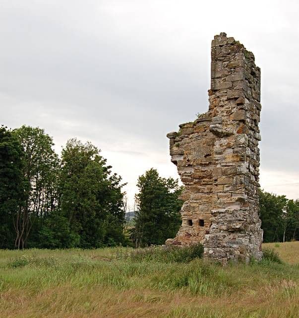
Aithernie Castle is a fragmentary ruin of a 16th–17th-century tower house located near Leven in Fife, Scotland. It stands on a slope overlooking the Scoonie Burn and consists mainly of a single corner of masonry rising four storeys high. The tower house was never intended as a true fortification; its large residential windows and lack of vaulting suggest a comfortable residence rather than a defensible castle.
Early history
The lands of Aithernie appear in charters from the reign of King David I (1124–1153), when they were held by Stephen de Aithernie. By 1220 the property had passed to the Lundin family, who held it from the earls of Fife. During the Wars of Independence the family supported Robert the Bruce’s rivals and lost their estates; in 1479 King James III confirmed grants of the lands to the bishop and church of St Andrews, which later leased Aithernie to the nunnery of North Berwick. In 1536 the Abbess of North Berwick feu-fermed the estate to John Carmichael, an Edinburgh burgess.
Building of the tower house
After the Reformation, the superiority of Aithernie passed to Sir Alexander Home and then through marriage to the Rigg family. William Rigg, an Edinburgh merchant, married Sarah Inglis and probably built the stone tower house in the early 17th century. The rectangular tower, possibly with an L-shaped plan, stood several storeys high and had timber-floored rooms on each level. A return in the masonry at the south-east corner shows the position of the ground-floor doorway, and the presence of window returns and joist holes on the upper storeys indicates multiple building phases.
Later ownership and decline
The Rigg family held Aithernie until 1670, when Thomas Rigg sold it to James Watson of Downfield. Watson passed the property to his son Alexander in 1692, and the family remained in residence for much of the 18th century. Local tradition blames Alexander’s wife, Margaret Lindsay, for the estate’s decline; her extravagance reportedly ruined the family fortunes. Despite this, Aithernie was still described by Sir Robert Sibbald in 1710 as a “fine house with gardens, orchards and parks”. Maps drawn by General Roy (c. 1755) and John Ainslie (1775) show the tower surrounded by formal grounds. By the early 19th century the building was in ruins; Sibbald’s 1803 reprint noted that Aithernie was already derelict, and the 1828 map by John Dower labels it “Aithernie Ruins”.
Present condition
Today Aithernie Castle consists of the north-eastern corner of the original tower, standing to a height of around six metres and surrounded by farmland. A short length of wall extends from the corner, but no other parts of the building survive. The remains are fenced off yet visible from the roadside, and visitors can reach the site under the Scottish Outdoor Access Code. The ruin provides a tangible link to the estate’s long history and to the fortunes of the families who once lived there.
Help Improve This Page
Help to document and preserve British castle heritage for future generations.
Share your photographs
Write and review content
Support the project